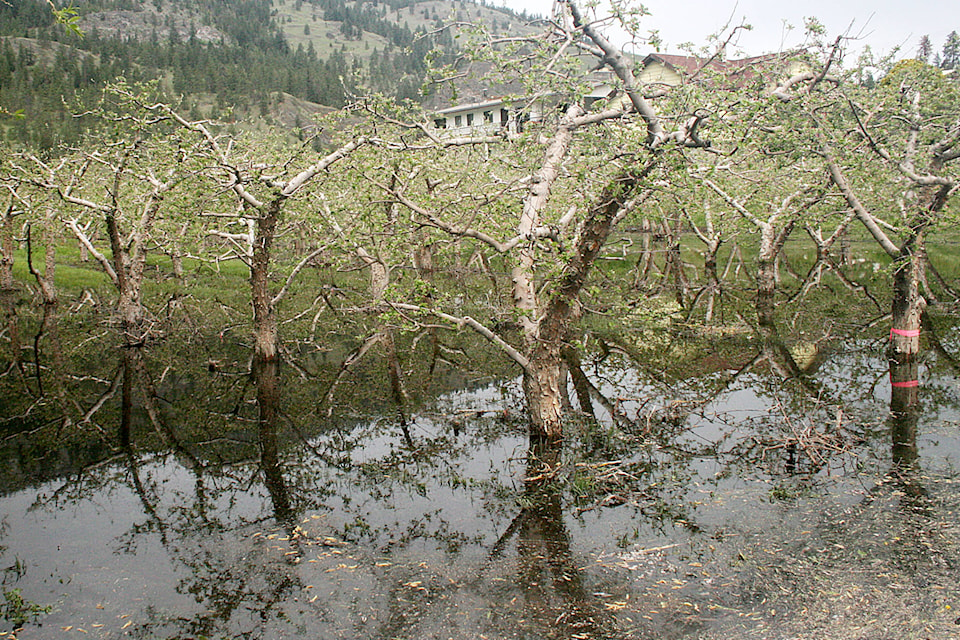
Flooding in the Garnett Valley area left some orchards and fields submerged over the weekend.
“We are on heavy watch and we have had some localized flooding to date,” said Linda Tynan, chief administrative officer for the municipality.
While flooding in Summerland was less severe than in other parts of the Okanagan Valley, rising water levels have had an effect here.
Before the weekend, Garnett Dam was already starting to spill and municipal staff were monitoring the water levels.
“We haven’t had Garnett spilling for quite a few years,” said Devon van der Meulen, manager of utilities for the municipality.
As a result of the spilling, the water level in Aeneas Creek is high and the municipality is offering sand and sandbags to those living near the creek.
Over the weekend, 1,600 sandbags were picked up. The municipality still has 12,000 sandbags available.
Because the creek is narrow, it has the potential to flood adjacent properties, van der Meulen said.
While the Garnett Valley area experienced flooding on the weekend, the situation is different in the rest of the community.
Thirsk Lake and Isintok Lake in Summerland’s reservoir system are rising rapidly and will soon begin to spill, but the high water levels are not expected to present risks to the rest of the municipality.
The latest snow course survey data, from May 1, show above normal levels at Summerland Reservoir and Isintok Lake.
At Summerland Reservoir, the snow depth was 500 millimetres, or the equivalent of 185 millimetres of water. This is 170 per cent of the historical average at this time of year.
At Isintok Lake, the snow depth measured 590 millimetres, or the equivalent of 174 millimetres of water. This is 136 per cent of the historical average.
Earlier this year, the snow measurements at both sites were well below the historical averages.
Melting water from these sites eventually makes its way into Trout Creek.
While temperatures were warm and sunny on Tuesday and Wednesday, rain was forecast for Thursday and Friday, Environment Canada meteorologist Doug Lundquist said.
“For Wednesday we are forecasting highs in the 26 C range and then Thursday and Friday we may get another 15 to 25 millimetres of rain, maybe even more, with the next weather system. There is certainly more concern coming up.”
Lundquist says while the initial snow pack that caused a lot of the flooding last week has now melted, there are several other higher-elevation snow packs that are now a concern.
“High elevation or different watersheds may see the snowpack melt. So when that happens with the rainfall coming on Thursday and Friday it is a concern,” said Lunquist.
While the water level in the creek is high, van der Meulen said Trout Creek is wide enough to handle increased water levels.
The water treatment plant is not expected to have problems from the high water levels as the intake allows only as much as the plant can handle.