The Penticton Indian Band has joined the majority of the South Okanagan-Similkameen in declaring a state of local emergency.
Band council issued the state of local emergency (SOLE) by way of a band council resolution, and the SOLE takes effect immediately, according to a news release.
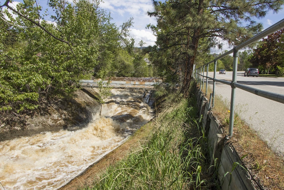
The SOLE was declared due to risks of flooding in Ellis and Shingle creeks, as well as local watersheds experiencing high water flows. The PIB also noted the potential for flooding on roadways “from groundwater inundation, which may threaten life, safety and cause significant property damage.”
Related: Water coming across Highway 3 west of Keremeos
A state of local emergency gives governments the power to suspend and/or change functions of elected officials, administration and police to address emergent situations, such as flooding or fires.
“It alerts citizens to change their normal behaviour and orders government agencies to implement emergency plans,” the release said.
“In the event that the situation deteriorates, residents will be given as much notice as possible through an evacuation alert, which may be followed by an evacuation order. Once evacuated, residents should leave the area immediately and register at the reception centre identified.”
Related: Evacuation alerts expanded in Similkameen
The City of Penticton has an emergency reception centre at the Penticton Community Centre gymnasium, however it is not clear if PIB would use the same centre.
The PIB joins all rural electoral areas in the Regional District of Okanagan-Similkameen and a number of municipalities, including Penticton, in declaring states of local emergency.
Flooding swelled in many areas in the region last week, but with hot weather this week and over the weekend, river and creek flow is expected to swell to new highs.
Related: Care home residents relocated due to flooding in Keremeos
The City of Penticton declared its state of emergency late last month to deal with issues in Penticton and Ellis creeks. Infrastructure manager Mitch Moroziuk said engineers identified a few spots in the creeks that needed work to reduce risks to the infrastructure.
“We’re not concerned at this point in time with Penticton Creek,” Moroziuk said early last week. “Yes, it’s flowing higher, it’s considerably higher than it was four days ago. It’s not at the level it was running last year, and we are monitoring it on a regular basis.”
Moroziuk said the city will only sandbag areas where there are flooding concerns along the creeks once they have come within a foot of the top of the bank.
Related: Penticton rushing to prepare creeks
“There’s only one area that (engineers) identified at this point in time,” Moroziuk said. “We’re also watching for things like trees that get knocked over and happen to get snagged against bridges. We will be removing those as we find out about them.”
He added that he did not expect to see the same kind of damage to the bridge into the Japanese gardens at the mouth of the creek.
“The main reason that happened, though, was because the lake was considerably higher, right so you’re getting what we call a … backwater condition, so the lake is higher, so then that means the creek coming down into the lake, it’s meeting the lake at a different location.”
Related: 5 things to know about B.C. Floods 2018
The city is also preparing for potential impacts of high water on Okanagan Lake, which has swelled by half a metre in the past eight-and-a-half days.
Currently, the lake is sitting at 342.32 metres, whereas last year the lake had hit 343.25 metres, making a difference of nearly a metre.
In a Tuesday afternoon news release, Moroziuk said estimates from the city and the province the lake is expected to rise another half-metre by Saturday to the 343-metre mark.
The city advises property owners along the lake to take steps to avoid flooding now, and if draining is required, to direct water onto Lakeshore Drive.
The city said it will be installing tiger dams, gabion baskets, rip rap and sandbags across the waterfront, from the SS Sicamous to the Okanagan Lake Marina.
“With crews and equipment working along the shore, the public is asked to follow all signs and directions and to exercise caution,” the city said. “Traffic will be interrupted periodically; nearby parking will be closed.”
The city added that it will be leaving wood debris on the lakeshore to mitigate wave action.