Update: Wednesday - 1:13 p.m.
Placer Mountain
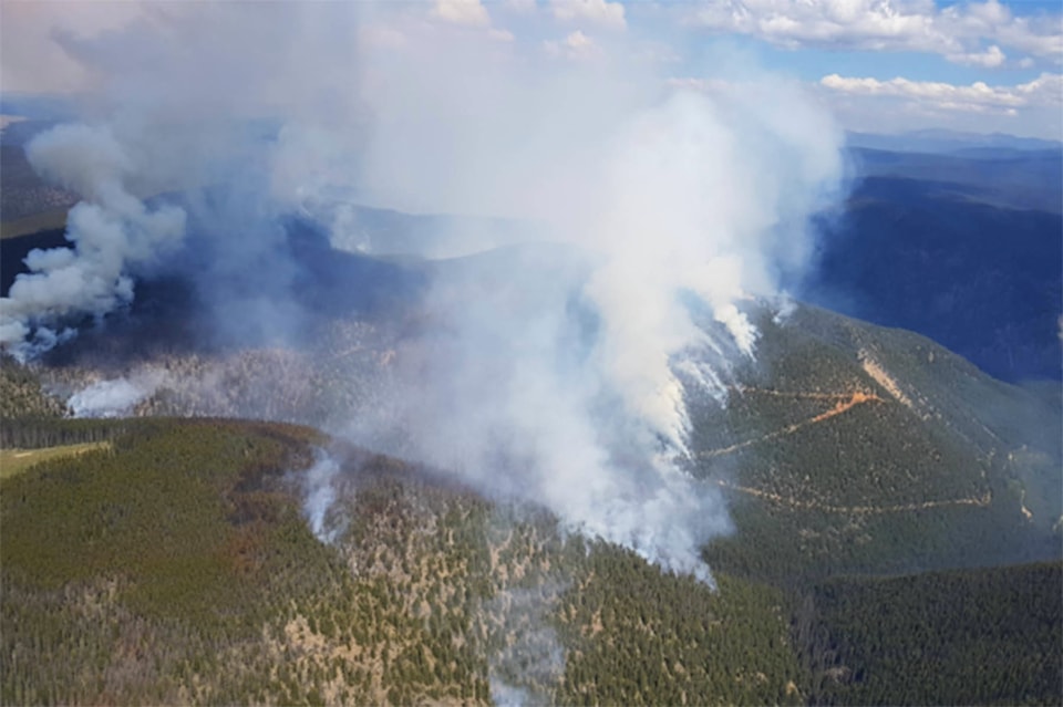
The Placer Mountain wildfire continues to grow south of Princeton. The blaze is now an estimated 520 hectares in size.
There is 22 firefighters, four helicopters and eight pieces of heavy equipment are on scene of this fire.
The fire has crossed McBride Creek and is progressing upslope into the old Diamond Fire of 2017.
According to Ken Juvik of the BC Wildfire Service says crews will continue establishing wet lines along hose trails.
“Bucketing is being carried out in areas where the fire is burning aggressively.Danger tree assessing and danger tree felling is ongoing,” stated Juvik.
Wednesday’s goal is to establish a contingency line to the west of the fire with heavy equipment.
There is no current evacuation orders or alerts, at this time. However, future road or area restrictions may be implemented due to traffic on the Ashnola Road.
Snowy Mountain
BC Wildfire Service is monitoring the Snowy Mountain fire with a remote camera that provides real time imaging.
According to Ken Juvik with the BC Wildfire Service, the fire is holding at 1,530 hectares, but is still classified as out-of-control.
“Land managers have been consulted and trigger points have been set to determine at what point this fire will be actioned,” stated Juvik.
The fire is burning at a high elevation and is visible to Cawston and Keremeos.
As this fire is located in the Snowy protected area, BC Parks has closed Ewart and Wall Creek trails pending further assessment of the fire.
There are currently no evacuation orders or alerts.
————
Update 8:30 p.m.
As of Tuesday evening the Placer Mountain fire was heading upslope into a portion of the high elevation backcountry that was burned last year during the 30,000 hectare cross border Diamond Creek fire.
The Diamond Creek fire burned for months, finally being put sometime during the winter months.
Related: Massive cross-border wildfire growing rapidly
The Placer Mountain fire has grown to 434 hectares in size, located west of Ashnola River and Cathedral Park and is still considered out of control. The fire is not active in Cathedral Park at this time.
All day crews worked to establish a three-metre wet line around the fire perimeter and complete danger tree assessments and danger tree falling. Work also continues on putting a dozer line in the East gully. The fire has crossed McBride Creek.
At this point no structures are threatened, but BC Wildfire Service reports, “future road or area restrictions maybe implemented due to traffic on the Ashnola Road.”
Currently, 22 firefighters, four helicopters, seven pieces of heavy equipment and industry personnel are actioning the fire.
The Snowy Mountain fire continues to grow and is now listed at 1,530 hectares in size.
A remote camera has now been set up and is providing real time imaging.
“Land managers have been consulted and trigger points are being set to determine at what point this fire will be actioned. It is burning at a high elevation and is not threatening any structures or infrastructure at this time. This fire is highly visible to surrounding communities,” a release from BC Wildfire Service stated.
Original:
The Snowy Mountain fire continues to grow, but because of its remoteness and difficult terrain BC Wildfire has yet to action the fire.
An update from BC Wildfire Service on Tuesday morning listed Snowy Mountain at 1,530 hectares in size, having grown about 200 hectares over the last 48 hours.
The fire is listed at zero per cent contained.
Related: Okanagan Wildfires: Tuesday morning update on wildfires and evacuations
The Snowy Mountain Fire, which has had several names since being discovered July 17 after lightning storm ripped through the area, is located in high elevation about 14 kilometers south of Keremeos.
The fire is located in the Snowy Protected Area and BC Parks has closed several trails including Ewart and Wall Creek Trails pending further assessment of this fire.
The fire is being closely monitored and a remote camera is being mounted to provide information about the growth of the fire.
The Placer Mountain fire, located west of Cathedral Park and east of Eastgate has grown to 434 hectares in size and is currently being actioned by BC Wildfire.
On Tuesday 22, firefighters, four helicopters, and seven pieces of heavy equipment were working the fire. Work Tuesday included putting in a three-metre wet line around the fire perimeter and completing danger tree assessments and tree falling. A dozer line in the east gully will also be completed.
Related: Wildfire near Keremeos still burning at 255 hectares
The only other small fire burning in the Lower Similkameen listed on the BC Wildfire Service interactive map at the time of this posting was the North Side of the South Slopes fire, which is listed at two hectares in size. The fire is in high elevation near the Ashnola River and was discovered July 19.
We will continue to update this story as more information comes available.