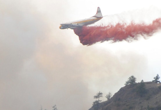
Wildfire activity is up slightly so far this year, with a warmer-than-normal summer expected to follow on the heels of a relatively dry spring.
Through last week, there were 69 blazes reported within the Kamloops Fire Centre, down from 66 in the same period in 2013, according to information officer Melissa Klassen.
Sixty of this year’s fires were human-caused.
“That’s a pretty normal ratio right now this early in the season given the fact we don’t have our major lightning storms until July and August,” Klassen explained.
And with the height of the fire season just around the corner, a lot is riding on what falls from the sky this month.
“Obviously we do receive a lot of our precipitation in June. That kind of moisture does predict in some ways for us what kind of fire activity or fire behaviour we’re going to see,” she said.
“It’s definitely wait-and-see. It’s too early in the season to tell.”
The fire danger rating in the Penticton area was low as of Tuesday, but, “If we’re seeing high temperatures one or two days in a row, that can drastically change our fire danger rating and dry out those forest fuels,” Klassen added.
That change could begin this weekend with Penticton forecast to reach a high of 30 C by Sunday.
Environment Canada meteorologist Allan Coldwells said residents can expect a summer that is about 1 C warmer than normal, thanks to the El Nino effect.
“All the models are in fairly good agreement there will be an above-normal trend,” Coldwells said.
He also noted that precipitation recorded through the first five months of the year at the Penticton airport was just 88 per cent of normal at a total of 120 millimetres.
“It’s not huge, but it is below normal,” Coldwells said, adding, “The trend is we’re staying below normal, precipitation-wise.”
While a lack of rain won’t improve B.C.’s fire situation, it could help on the flooding front.
“The risk going forward really is going to be related to if we see any kind of severe rain,” confirmed Dave Campbell, head of the B.C. River Forecast Centre.
He said although the snowpack in the Okanagan basin was at 123 per cent of normal as of June 1, and at 167 per cent in the Similkameen, those figures are somewhat skewed because they’re based on fewer readings from higher elevations where most of the snow is left.
“Warmer weather in May has melted off quite a lot of the snow at mid-elevations and so for a lot of those areas they are snow-free now, and in terms of how that’s impacting river flow and flood potential, there’s a real decrease in the risk right now,” he said.
Even if a good amount of rain does come, Campbell added, “I think we’ve got enough room in the rivers that it isn’t posing any risk at this point.”